✦   EXCLUSIVE DOSSIER   ✦

Flood-recession
agriculture
in the Senegal River Valley

Memory, water and adaptation
at the edge of the river

SCROLL

Senegal River Valley  ·  Futa Toro  ·  Mauritania–Senegal Border

A landscape shaped by water, memory, and millennia of patient knowledge.

The Land

Where the Sahara
meets the river

The Senegal River travels 1,641 kilometres from the Fouta Djallon highlands of Guinea to the Atlantic at Saint-Louis. For more than 830 km it draws the border between Mauritania and Senegal — a lifeline separating desert from savannah.

The alluvial valley — called Chemama on the Mauritanian side and Waalo on the Senegalese side — stretches up to 35 km wide during peak floods. Here, in this fertile belt squeezed between the Sahara and the Sahel, a millennia-old system thrives: flood-recession agriculture.

The village of Louguere Dadi, in the Kaédi region of Mauritania, is one such place — where earth and water still speak in ancient rhythms, and knowledge is not written down. It is passed on.

1,641km length of the Senegal River
450kkm² total drainage basin
15M+ people dependent on the basin
35km maximum floodplain width
Senegal River Valley · Aerial View
Louguere Dadi · GIS Map
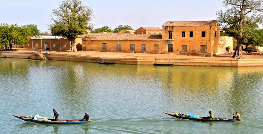
Senegal River · Traditional Pirogues
"

No irrigation. No chemical fertilizer.
Just seeds, soil, and traditional knowledge.

— Amadou Hamadi Diallo
01

The Rhythm

The rhythm of
the Senegal River

In the Senegal River Valley, where the border between Mauritania and Senegal is located, the same river that marks the boundary of my home village "Louguere Dadi" in Mauritania, farmers there have been using flood-recession agriculture for centuries. There, as the annual floodwaters recede, they plant niébé (Vigna unguiculata), maize (Zea mays), and other crops in riverbanks that are moistened and made fertile by the receding floodwaters. No irrigation. No chemical fertilizer. Just seeds, soil, and traditional knowledge, the same knowledge my grandfather taught me when I was a boy, planting black-eyed peas in the mud with only our hands and a crude hoe.

The agricultural practices in the Senegal River Valley have traditionally followed the natural rhythm of the Senegal River itself. During the rainy season, heavy rainfall occurs in the Guinean and Malian areas in the headwaters of the Senegal River. This results in the river overflowing its banks and flooding the Senegal River Valley. This flooding brings with it fertile soils rich in organic materials and nutrients, which result in naturally fertile soils in the Senegal River Valley (Bruckmann et al., 2025). At the end of the rainy season, the Senegal River slowly recedes from the Senegal River Valley, leaving behind wet lands that are ready for cultivation without any additional irrigation.

For centuries, farmers in the Senegal River Valley have been using this natural flooding to cultivate their lands and produce their agricultural products. This type of cultivation is known as flood recession cultivation and utilizes the residual moisture and fertility provided by the flooding river. Unlike other types of cultivation, flood recession cultivation does not require any additional resources such as pumps and fertilizers, but rather an understanding of the river and its seasonal flooding patterns, which has been built up over centuries of observing and understanding the river and its effects on the Senegal River Valley (Bruckmann et al., 2025).

In addition to the river itself, during the rainy season and because of flooding, several seasonal lakes and depressions throughout the valley also retain water. Once the floods have subsided, these wetlands can hold water for several months, giving farmers more time to cultivate their land by taking advantage of the soil moisture. In the Senegal River Valley, the river, the floodplain, and the seasonal lakes combine to form a dynamic landscape that supports livelihoods and agriculture.
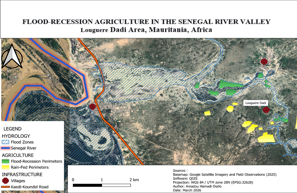
Map of the Louguere Dadi area in the Senegal River Valley
Figure 1 — Map of the Louguere Dadi area in the Senegal River Valley showing flood-recession and rain-fed perimeters, flood zones, villages and the Kaédi-Koundel road. Source: Amadou Hamadi Diallo / Bruckmann et al., 2025
02

Following the water

Following the water,
planting as the
river retreats

When the waters start to recede, the farmers follow. The farmers do not wait for the waters to completely go away. Instead, they follow the waters as soon as the land appears, day after day, planting behind the retreating waters. They know the time to start planting has come when the land feels just right, neither too wet nor too dry. If the land is too wet, the seeds will rot in the ground. If the land is too dry, the seeds will never come up from the earth.

The land may be moist for weeks, for months, because of the waters that have retreated from the land. This moisture will provide for the crops from planting time until harvest time, with no need to irrigate the land with additional water. Planting is easy, dig a hole, put in the seeds, and cover it with soil. No need for fertilizers because the waters have already taken care of that for you, leaving a layer of fresh earth that will provide for your crops as they grow from the earth.

Take a walk along the riverbank during planting season, and you will see something beautiful, small plots of land everywhere, marked with fences made of branches or dried crop stalks. The fences are to keep animals from eating the crops. The fences are boundaries, small statements of intent, here food is growing.

River scene on the Senegal River — pirogues
River scene on the Senegal River — pirogues have always been the artery of mobility, trade, and memory between both banks.

On the River

"The fences are boundaries — small statements of intent: here, food is growing."

Along the Senegal River, the pirogue is more than a boat. It is a symbol of the connection between two nations, two peoples, and one shared river — navigated by those who have read its moods for generations.

"

The scientists with their computer models
may not know.
My grandmother knows.

— Amadou Hamadi Diallo
03

Knowledge

Knowledge passed down
through generations,
reading the sky, wind and land

How do farmers know when it is time to plant? The answer is not in any books. The answer is in the mind of the elder, passed down through generations. My grandmother is in her eighties. She knows the rains will come in a few months. The sky speaks of the rains even before the rains arrive. The wind changes from a dry wind to a warm, humid wind with the scent of change. The sky is filled with big white clouds, indicating the rains will be heavy. The animals confirm the message of the sky. The birds start coming or dancing in the air. The cows start giving birth. We call this time of the year "Deminare" in Pulaar. When it is time for Deminare, we go with the cattle to follow the rains and then return with the pasture.

Sometimes the cattle go on their own. They smell the rain before we do. My grandmother taught me to listen for the Francis puddle frog. When the rains are about to start, the frogs start coming out in the temporary ponds. At night, the frogs sing in the air. We say they are saying, "May God bring rain." When the frogs sing, it is time to start preparing the fields. When the rains stop, the Savannah monitor comes out of hiding. The females start laying eggs. The sun is very hot. This is the sign that the rainy season is over. We call this time of the year "Kaawle", the time of the transition from the wet season to the cool dry season.

My grandmother knows the rains will come in a few months. She looks at the trees, birds, frogs, and monitors. The scientists with their computer models may not know. My grandmother knows. The wind tells us. The birds tell us. The frogs, monitors, and cows tell us. We just need to listen and remember.

PULAAR VOCABULARY

Deminare

The start of the rainy season; associated with transhumance and new life. When the frogs sing, the fields awaken.

Kaawle

The transition from the wet season to the cool dry season. When the monitor emerges, the harvest nears its end.

Senegal River Valley · The floodplain
Traditional life · The river
04

Resilience

A resilient and sustainable
system in a
changing climate

Flood-recession agriculture is a type of low-input, sustainable agriculture that utilizes natural flooding rather than irrigation. Niébé (Vigna unguiculata) is the main crop, which is used to enrich the soil by fixing nitrogen, while maize and sweet potato provide dietary variety. Floodplains offer ecosystem services such as groundwater recharge, wildlife habitats, and sediment transport.

14,000 — 75,000

HECTARES OF FLOOD-RECESSION CROPLAND

Bruckmann et al., 2025 & Sall et al., 2020 — varies with annual flood intensity

However, this type of farming is currently being threatened by various factors. Climate change, together with the construction of the Diama Dam, have resulted in unpredictable flooding, shorter growth periods, increased soil salinity, and unpredictable rainfall. In my village, Louguere Dadi, animals such as cattle, goats, and wildlife destroy crops even before harvest time, while branch fences do not always help to protect farm crops.

Despite all these challenges, there is hope for flood-recession agriculture. Much of the land is not fully utilized, and there is a possibility of reviving it. Recommendations have been put forward to help revive this type of farming, which includes:

This type of farming is worth investing in, as it would help restore land, support farmers, conserve the environment, and ensure water is saved for future use.

"

The River has changed before. It will change again.
We watch. We learn. We adapt.
That is what we have always done.

— Amadou Hamadi Diallo's grandmother

PART II

🌿 Applications & Insights

What gardeners and farmers can learn from
flood-recession agriculture

Flood-recession agriculture is not only a local practice. It reveals a broader principle: crops can be grown using stored natural moisture, without continuous irrigation, when soil, timing, and observation are aligned.

💧

Water storage
in the soil

rather than surface irrigation

🌱

Natural nutrient
deposition

brought by flood sediments

👁

Precise timing

based on environmental observation

01

Working with residual soil moisture

Instead of watering frequently, aim to store water in the soil so it serves your plants over time — just as the floodwaters serve the valley.

HOW TO DO IT

  • Deep watering at longer intervals
  • Cover soil with organic mulch (straw, leaves, wood chips)
  • Avoid unnecessary soil disturbance

✦  WHAT IT GIVES YOU

Mulch reduces evaporation and locks humidity in the root zone. Result: fewer waterings, more drought-resistant plants, healthier living soil. Already used in dry gardening and Mediterranean systems.

02

Timing planting with soil conditions, not calendar dates

In flood-recession agriculture, planting does not follow fixed dates. It follows soil readiness. This is one of the most transferable principles for any gardener.

WHAT TO OBSERVE

  • Soil moisture (not too wet, not too dry)
  • Soil temperature (critical for germination)
  • Weather patterns over several days

✦  WHAT IT GIVES YOU

Planting too early in wet soil = rot. Too late in dry soil = poor germination. The key is not "when" but "in what condition." Better germination rates, stronger starts, less waste.

03

Using natural fertility instead of constant inputs

Flood-recession systems rely on sediment deposits rather than fertilisers. The river feeds the land. In your garden, the compost feeds the soil — not the plant directly.

PRACTICE THIS

  • Compost inputs instead of synthetic fertilisers
  • Green manures and cover crops
  • Let organic matter decompose on site

✦  WHAT IT GIVES YOU

A self-sustaining, living soil that improves year after year. Better water retention, microbial activity, structure. Less dependency on external inputs — and a lower cost garden.

04

Creating micro-conditions that retain water

Without a river, you can recreate similar effects by shaping your landscape. Even modest interventions hold water longer where roots need it.

SIMPLE TECHNIQUES

  • Slight depressions to collect rainwater
  • Raised edges to prevent runoff
  • Planting in basins rather than flat soil

✦  WHAT IT GIVES YOU

Water stays longer in the root zone. Less frequent irrigation, stronger drought resilience. Similar to zaï pits in the Sahel and basin planting in arid zones worldwide.

Who is this useful for?

🌞 Dry & Mediterranean climate gardens 💧 Water-restricted areas 🌿 Low-input ecological projects 🏙️ Urban gardeners reducing watering 🌾 Regenerative agriculture practitioners 🔬 Researchers in agroecology

Limits and precautions

Flood-recession agriculture depends on very specific environmental conditions. Direct replication is not possible everywhere. Key constraints include soil type (sandy soils lose water faster), rainfall patterns, and access to organic matter. Rather than copying the system, the goal is to adapt its logic to local conditions.

A broader perspective

This system invites a shift in perspective. Instead of controlling water, farmers follow its movement. Instead of imposing a schedule, they respond to the environment. This approach can be found across many traditional farming systems worldwide — where observation replaces standardisation.

Final insight

Flood-recession agriculture shows that productivity does not always depend on more inputs. It can also emerge from timing, observation, and a deep understanding of natural cycles.

In a context of increasing water scarcity, these principles may become not only relevant — but necessary.

References

Amadou Hamadi Diallo

About the Author

Amadou Hamadi Diallo

Louguere Dadi · Senegal River Valley · Mauritania

Agricultural engineer and PhD researcher in Climate Change Mitigation at Voronezh State Agrarian University (Russia). Holder of an MSc in Environmental Management (Pan African University / University of Ibadan, Nigeria) and a professional degree in Agricultural & Biosystems Engineering (ISET Rosso, Mauritania — 2nd in class).

Amadou's research focuses on CO₂ emissions from agrocenoses and climate change adaptation in agricultural systems. Expert in GIS, remote sensing, and land use analysis, he is the author of a Scopus-indexed publication on land use and land cover change in Southwest Mauritania.

Deeply rooted in the traditional farming communities of the Senegal River Valley, he documents flood-recession practices transmitted across generations at the Mauritania-Senegal border — bridging scientific research with indigenous knowledge.

This article is part of the Vergers du Monde — Terrain Report Series.